
Stage route
The 17th stage unfolds over a varied and complex 200-kilometer route, alternating fast sections with more technical stretches. The course passes through several towns and natural areas, shaping a dynamic stage that requires careful energy management.
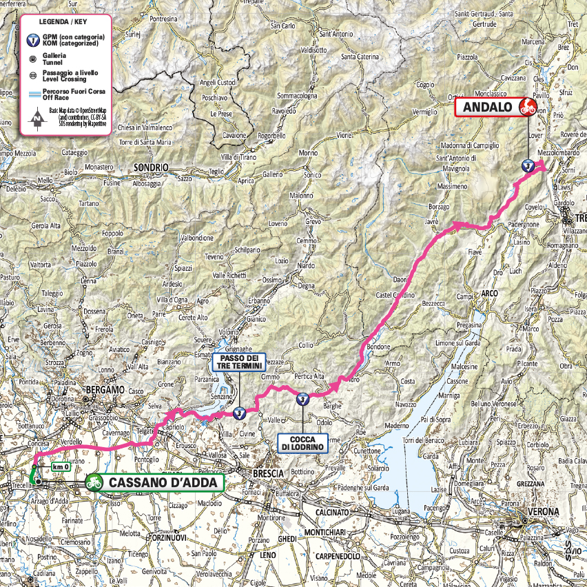
The elevation profile highlights the challenges of the stage, with climbs spread along the route and potential decisive points in the finale. The stage starts at 150 meters above sea level and reaches 1,010 meters, with an elevation gain that becomes progressively more demanding after a steadier opening section, putting the riders’ endurance to the test.

City route
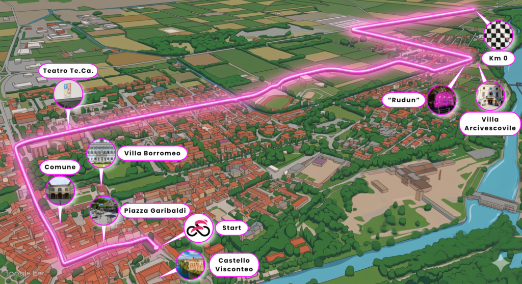
Kilometre 0 address: provincial road 104.
Coordinates: 45° 33’ 21.92″ N – 9° 31’ 1.28″ E
Distance from start to kilometre 0: 5,160 metres
| DIRECTION | STREET |
|---|---|
| Start | Piazza Cavour |
| Left turn | Piazza Garibaldi |
| Right turn | Via Vittorio Veneto |
| Roundabout, right turn | Via Europa |
| Roundabout, continues straight | Via Papa Giovanni the 22nd |
| Roundabout, right turn | Via Papa Pacelli |
| continues straight | Ponte azzurro |
| Left turn | Via Cassano |
| Left turn | Via Calambiana, Ponte La Grande Ruota |
| Roundabout, continues straight | Via Cimbardi |
| Roundabout, right turn | Provincial Road 104 |
| Kilometre 0 | Provincial Road 104 |
Traffic plan
Starting from 9:00 AM, the Giro Village will open in Via Dante and Via Manzoni, featuring entertainment activities, live music, and the distribution of gadgets.
In Piazza Perrucchetti, the hospitality area and the signature podium will be set up.
DOWNLOAD THE ROAD CLOSURE NOTICE HERE
In order to ensure the smooth running of the event and allow the setup of structures, the following measures will be implemented:
- Tuesday, May 26: no parking and no traffic along the roads affected by the passage of vehicles, from 4:30 PM to 6:30 PM.
- From Tuesday, May 26 at 4:30 PM to Wednesday, May 27 at 6:00 PM: no parking and no traffic in the Village area, hospitality area, signature podium, and starting zone.
- Wednesday, May 27: road closures on affected streets from 7:00 AM to 1:00 PM, with times varying depending on the race passage.
- Wednesday, May 27: no parking with forced removal along the entire route, from 5:00 AM to 1:00 PM.
Regarding the temporary suspension of traffic, please refer to the specific ordinance issued by the Local Police.
YOU CAN CONSULT THE INTERACTIVE MAP WITH DETAILS OF THE STREETS AFFECTED BY TRAFFIC AND PARKING RESTRICTIONS
During the suspension period and until the end-of-race vehicle has passed, in compliance with the instructions given by officials and organizers:
- no unauthorized vehicle may travel on or enter the race route;
- vehicles already on the route or needing to cross it will not be allowed to move;
- pedestrians are prohibited from crossing the roadway involved in the race.
School closures
For the entire day of May 27, 2026, schools will be closed and/or educational activities suspended for:
- schools of all levels;
- early childhood education services, both public and private.
This measure is adopted in accordance with the competent authorities, in order to avoid disruptions to transport and ensure adequate safety conditions for residents, spectators, athletes, and staff involved.
Municipal offices
On the same day, municipal offices may have changes to their public opening hours.
Final provisions
In light of the above, citizens are invited to actively cooperate to ensure the safety and success of the event.
Thank you for your cooperation in helping welcome an international sporting event.
Any further updates and information will be communicated promptly.